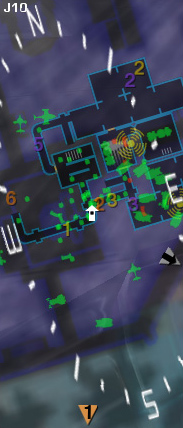
Proximity Map

Also known as the "Radar," the Proximity Map is typically located in the top left of your Heads-Up Display (HUD) and shows a wealth of data.
Friendly units are displayed in Green. Enemy Units are displayed in Red.
Depending on certain variables such as Motion Sensors or control of an Interlink Facility, some Enemy units may or may not show up on your Radar.
When you are outdoors, by default, your Proximity Map displays a map 200m in radius. When approaching a base, the zoom level changes to 100m for an easier view of nearby troops. When you are indoors, the 50m setting will show the layouts of the various rooms that can be found on your current level, making navigation within Facilities much easier.
There are two orientation modes, toggleable via the menu:
- Map-rotate mode, which will turn the map and always show you facing upwards, and
- Player-rotate mode, which always shows North upwards and will rotate your arrow to indicate your heading.
If you have the Advanced Medical certification and equip the Medical Applicator, fallen soldiers will be shown as glowing triangles. If you are a fallen soldier, friendly Advanced Medics holding Medical Applicators will be shown as glowing crosses (Advanced Medics will see this as well when holding a Medical Applicator).
Personal, Squad, and XP Waypoints will show up on your proximity map if they are within display range, or they will indicate the direction to them if they are not.
In the upper-left of the pane, small white text indicates your coordinates on the continental map.
You can toggle the Map on and off from your Soldier Management Bar, located at the bottom right of your HUD.
The Proximity Map is also called the Proximity Radar, Radar Map, or, incorrectly, the Overhead Map.